Map Tracking COVID-19 in Tulare County
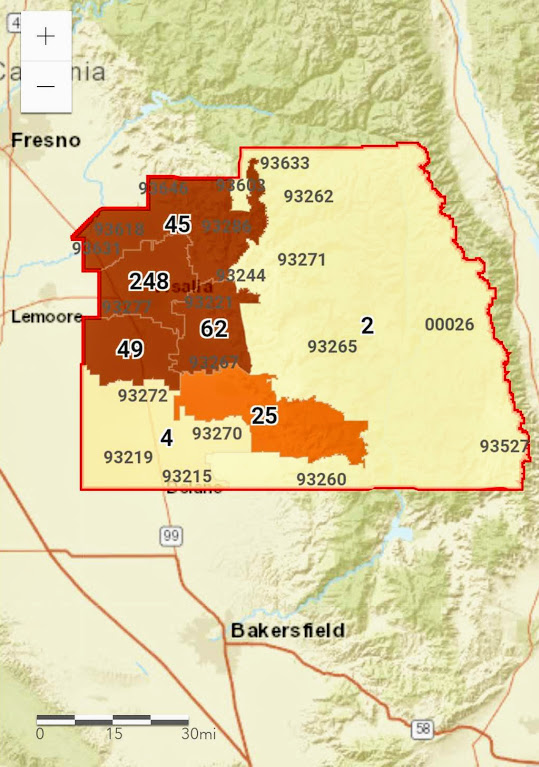
Photo Courtesy of the Tulare County Health and Human Services Agency
As of Monday, Apr.20th, the county had 436 cases, 62 recoveries and 22 deaths. The number is expected to rise all over the state as the curve continues to slowly flatten.
The Tulare County Health & Human Services Agency have added a new tool to track the spread of the novel Coronavirus. On their official website the agency offers a map of active cases broken up by zip codes and areas of the county.
The county is broken up into 7 areas each with at least 2 cases confirmed in each area. The areas of the county are North County, Visalia Area, Tulare Area, South County, Exeter-Lindsay Area, Porterville Area, and the Sierra and National Parks area. As of now the urban areas, Visalia and Tulare, have the most cases while rural areas have fewer, but mostly double digit numbers.
On Monday, Apr. 20th Tulare County announced the most cases and more deaths than any county in the Central Valley combined. Almost 250, about 57 percent of the county’s total, are in the Visalia area. Most cases are particularly in the Redwood Springs Retirement Facility which once held 50 percent of the county’s cases.
The map can be found on the Agency’s website and is updated whenever the county updates their numbers which is almost daily. For more information on COVID-19 call 211. The map can be found here.